This
morning we are on our way to the Lakefield National Park
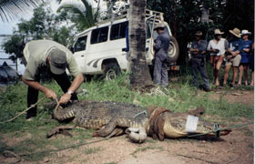
to meet Dr. Mark Read. He is going to help us catch a crocodile.
No, the teams are not breaking hunting laws and we are not
trying to hunt down our dinner. We are donating a satellite
tracking system for the research of the salt-water crocodile.
The gadget was developed especially for the Isuzu Challenge
as part of its annual donation to help global ecological
causes.
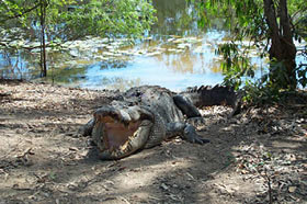
The estuarine crocodile, Crocodylus Porosus, is a reptile
that inhabits reef coastal and inland waterways in much
of Queensland, Australia. Over the years the crocodiles
here were hunted and their numbers are now severely depleted
– they became protected in 1974.
Since the early 1980s, staff from the Queensland Parks and
Wildlife Service (QPWS) has conducted hundreds of surveys
to determine the population of estuarine crocodiles. Unfortunately,
given the scope and logistical constraints of their research
and monitoring program, there has been a limited ability
to study the life of the crocodiles.
To
date, QPWS has virtually no information on the crocodile's
movement patterns, or whether movements are contained within
a defined geographical area (a ‘home range’).
In addition, QPWS has no data on whether movements change
with the size of the animal, its sex or reproductive status,
or with changes of the season.
Detailed knowledge about where they go is critical for the
long-term management of the species in Queensland.
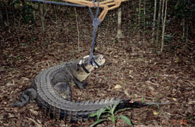
Charting the movements of any wild animal is difficult,
but when the creature is also shy, semi-aquatic and potentially
dangerous, it becomes particularly difficult. The most suitable
method to log adult-sized estuarine crocodiles is to use
satellite telemetry.Its
advantage is that location data is recorded via satellites,
without the observer needing to be nearby.
This technique has been used to study the movement of birds,
camels, elephant seals and several species of turtle.
The overall aims of this project are to attach a GPS transmitter
to an adult crocodile residing within Lakefield National
Park and track it for 10 to 12 months. Data will be shared
on a web page.
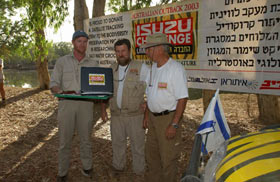
Mosh Savir, president of the Geographical Tours Company,
presented the satellite tracking systems to researchers
and said: “Every year we choose a green goal linked
to global issues and make a donation to projects at a local
level. In addition to this specific donation, the exposure
that we have brought to the endangered crocodiles is also
important."
After the donation ceremony, we say goodbye to the nature
reserve rangers, to Dr. Mark Read, and to the crocodile,
and head toward our final destination of the northernmost
point of Australia – Cape York. One more day and we’ll
be there.
Photographer
: Gerry Avramovich