Garmin
GPSIII Plus
The
GPS III Plus has a 4 level LCD screen, which measures 2.2 x
1.5". Yes, it is small, but it is plenty to tell you everything
you need to know in most cases.
The
unit can handle 20 routes with up to 30 waypoints per route.
This is usually more than enough, unless you plan on going around
the world without ever archiving your GPS.
We
mentioned earlier that the GPSIII Plus comes with maps already
built in. Here's the scoop on the basemaps. The Americas Highway
basemap includes, the United States, Alaska, Canada, Mexico,
and Central and South America. The standard map coverage includes:
- Oceans,
rivers, and lakes (greater than 30sq. miles)
- Principal
cities and many smaller cities and towns
- Major interstates
and principal highways
- Political
boundaries (state and International borders).
- Small lakes,
major streams, and rivers
- Principal
urban areas (including AL and HI)
- National
and State level roads
- Many local
roads in or near urban areas
- More detailed
coastline
- Airports
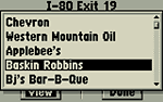
- Database
of exits for the Federal Interstate Highway System, including
businesses withing about 1/4 mile of the exits, including restaurants,
gas, hotels, RV parking, dumps, campgrounds, truckstops, medical
facilities, shopping and outlet malls, ATMs and many more attractions.
That's quite
a bit of stuff! If that's not enough for you, you can also upload
additional information from a MapSource CD, including trip plans,
topographical information, and more detailed maps.
When you turn
on the unit for the first time, you will need to initialize the
unit. This is a simple job and you can do it either automatically
or you can use the direction button on the unit to guide the cursor
to your approximate location.
Map Screen |
Copmpass
Screen |
Viewing
nearby restaurants |
The GPSIII
Plus has six main pages or screens that are used during navigation.
Pressing the PAGE or QUIT buttons will cycle through them. Here
is a VERY brief overview that just barely touches on what these
pages do. We have left out some functions to keep it simple.
- Satellite
Status: This shows you graphically, which satellites have
been acquired by the unit and what their strength is. There
is also a battery level indicator.
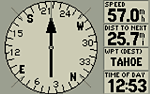
- Position:
This shows you where you are, numerically. A graphic compass
display is at the top and shows you your direction of travel
(track). Below, are six selectible data fields where you can
display info such as speed, trip timer, sunrise, sunset,
avg. speed, etc.. At the bottom, current position is listed
in coordinates, current time and date.
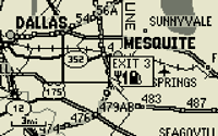
- Map:
Always our favorite. Personally, I can't get enough of watching
myself move around on a map. Garmin's GPSIII Plus is incredibly
accurate. Any time I have zoomed in very close, I have always
found myself to be right on top of a road. Rarely do I find
the GPS showing me off the road (unless I really am). Maps can
be easily zoomed in and out using the appropriately named IN
and OUT buttons. You can also move around anywhere you
like using the position buttons with your thumb. Moving the
cursor around, you can see the coordinates change at the bottom
of the screen. You can also see the distance to that point.
By pressing the GOTO button, you set the map point as
a waypoint and the GPS will guide you there. It will also draw
a straight line to that point. You can set the Garmin to split
the map display. A smaller section can then display up to four
user-defined pieces of information, similar to on the Position
screen. You can even set one to be an arrow which you can look
at to find your way. You have your choice of scrolling modes
on the map. One way is North Up and the other is Track Up.
- Compass:
This is just what it says. It's an electronic version of a hand-held
compass. Like the other screens, this one can also display up
to four user-defined pieces of information.
- Highway:
The highway screen is split three ways. The top shows a compass
similar to the Position page. The right side displays the now-familiar,
four user-defined sections. The main part shows a simulated
highway. Imagine looking down a long road. Each waypoint along
the way is displayed much like a road sign as you pass by. If
you deviate from your path, the road will go off-screen and
you will know to follow the arrow to get back on track.
- Active
Route: Shows the selected route if there is one, and includes
Waypoints and Course.
More
--->>>
©
2000 Rockcrawler. All Rights Reserved
|