 NEW
YORK, LONDON, PARIS…MOAB!
NEW
YORK, LONDON, PARIS…MOAB!
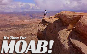
There
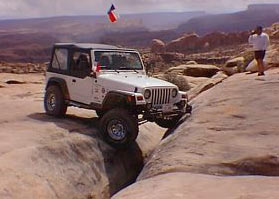
really is no place like it on Earth. Moab, Utah is a great little
town surrounded by arguably the coolest four-wheeling on the planet.
The area surrounding Moab is a haven for mountain bikers, rafters
and, of course, four-wheelers. The area looks like the surface of
Mars with sandstone rising up from the valley floor. The area contains
some of the most amazing scenery and trails you will ever see.
SLICKROCK!
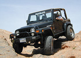
There
are many stories for how the sandstone in the area became known
as slickrock, but the name can be misleading. In the old days
of the cattle drives, during rains cattle would lose their footing
on the wet sandstone. However, when dry, the rock provides more
traction than most streets, providing a unique four-wheeling experience.
Some obstacles in Moab are too steep to walk up, but can still
be driven up. The slickrock offers such great traction that even
unlocked rigs can have fun doing things they never thought possible.
TRAILS
& CRYPTO!
To the
uneducated eye the area surrounding Moab looks like an uninhabited
rock pile. The truth of the matter is exactly the opposite. The
area is really a fragile desert ecosystem. It is VERY important
to stay on the marked trails.
 A
loose crust-like soil, called cryptobiotic soil resides here.
This living soil is extremely volatile and even the slightest
damage to it can take generations to recover, and may not ever
fully recover. The soil is important, because it helps guard the
desert landscape from wind and water erosion. Even walking across
it can disrupt the ecosystem. This is one reason why it is so
important to stay on the trails. Responsible four-wheeling in
this area is crucial to the future of this area and our ability
to use it. To learn more about cryptobiotic soil, visit www.gorp.com/gorp/resource/us_national_park/ut/cry_arch.htm.
A
loose crust-like soil, called cryptobiotic soil resides here.
This living soil is extremely volatile and even the slightest
damage to it can take generations to recover, and may not ever
fully recover. The soil is important, because it helps guard the
desert landscape from wind and water erosion. Even walking across
it can disrupt the ecosystem. This is one reason why it is so
important to stay on the trails. Responsible four-wheeling in
this area is crucial to the future of this area and our ability
to use it. To learn more about cryptobiotic soil, visit www.gorp.com/gorp/resource/us_national_park/ut/cry_arch.htm.
GPS Trail
Head Coordinates. (Selective availability)
If you are planning to head out to Moab, we have provided GPS
coordinates for many of the popular trailheads.
GPS information courtesy of "Guide to Moab, UT Backroads
& 4-Wheel Drive Trails" by Charles A. Wells. VIsit
his site at www.Funtreks.com.
1. Klondike
Bluffs : 38°44'26.2"/109°44'01.0"
2. Tower Arch: 38°47'43.1"/ 109° 39'26.8"
3. Tusher Tunner: 38°43'37.1"/109°43'17.0"
4. Hidden Canyon Overlook: 38°44'53.7"/109°44'13.8"
5. Hidden Canyon: 38°44'53.7"/109°44'13.8"
6. Bartlett Overlook: 38°37'43.8"/109° 48'03.8"
 7.
Sevenmile Rim: 38°40'48.5"/ 109°41'29.1"
7.
Sevenmile Rim: 38°40'48.5"/ 109°41'29.1"
8. Rainbow Terrace: 38°41'10.8"/109°55'19.5"
9. Secret Spire, Dellenbaugh Tunnel: 38°41'04.3"/109°54'56.4"
10. Spring Canyon Point: 38°41'26.9"/109°52'53.2"
11. Spring Canyon Bottom: 38°38'33.6"/109°49'12.7"
12. Hey Joe Canyon: 38°37'17.9"/110°00'05.5"
13. Mineral Point: 38*35'12.9"/109·48'18.3"
14. Mineral Bottom: 38°34'59.0"/109°48'01.7"
15. Gemini Bridges: 38°39'22.3"/109°40'35.1"
16. Metal Masher: 38°39'22.0"/109°40'34.3"
17. Long Canyon: 38°32'41.8"/109°45'48.9"
18. Bull Canyon: 38°39'22.3"/109°40'35.1"
19. Gold Bar Rim: 38°35'59.2"/109°44'22.7"
20. Poison Spider Mesa: 38°32'00.9"/109°36'24.8"
21. Golden Spike: 38°33'44.2"/109°35'43.9"
22. Cliff Hanger: 38°31'26.9"/109°36'04.9"
23. Hurrah Pass: 38°32'00.1"/109°35'59.6"
24. Moab Rim: 38°33'34.7"/109°34'56.4"
25. Pritchett Canyon: 38°32'08.2"/109°35'55.7"
26. Pritchett Arch: 38°25'15.8"/109°25'55.4"
27. Kane Creek Canyon: 38°27'58.0"/109°36'02.4"
28. Behind the Rocks: 38826'24.0"/109°25'44.2"
 29.
Picture Frame Arch: 38°25'15.8"/109°26'02.4"
29.
Picture Frame Arch: 38°25'15.8"/109°26'02.4"
30. Flat Iron Mesa: 38°21'26.0"/109°26'02.4"
31. Hell's Revenge: 38°34'31.2"/109°31'19.2"
32. Fins & Things: 38°34'47.7"/109°29'55.1"
33. Porcupine Rim: 38°34'54.7"/109°24'55.8"
34. Sand Flats Road: 38°34'31.3"/109°31'21.4"
35. Steel Bender: 38°32'16.5"/109°28'23.6
36. Onion Creek, Fisher Towers: 38°43'27.0"/109°21'17.8"
37. Top or the World:38°48'37.9"/109°18'16.0"
38. Rose Garden Hill: 38°41'20.6"/109°13'12.4"
39. Thompson Canyon: 38°38'41.9"/109°09'24.6"
40. Geyser Pass: 38°29'11.9"/109°18'58.8"
41. La Sal Pass: 38°26'02.1"/109°20'17.8"
42. Shafer Trail: 38°30'26.8"/109°39'38.2"
43. Lathrop Canyon:38°28'18.8"/109°48'36.8"
44. White Rim: 38°28'19.2"/109°48'36.7"
45. Chicken Corners: 38°28'54.5"/109°37'28.5"
46. Lockhar Basin: 38°25'45.6"/109°41'18.6"
47. Colorado River Overlook: 38°10'01.4"/109°45'32.2"
48. Elephant Hill: 38°08'31.5"/109°49'34.9"
49. Salt Creek/ Horse Canyon:38°09'00.4"/109°45'15.9"
50. Lavender Canyon: 38°09'10.6"/109°37'37.2"