As part of a legal settlement with anti-access groups, the BLM in Utah is reviewing travel management plans in 13 travel management areas. This is a process that will impact thousands of miles of roads, and since almost all forms of outdoor recreation on public lands relies initially on motorized access, this process affects everyone who recreates on Utah’s BLM lands.
We have been actively engaged in protecting access for motorized access during this process. In order to get as many people involved we created the 10,000+ Project, where you can sign up to assist us with public comments, route inventory analysis, and other activities that allow us to work together to protect access.

https://www.sharetrails.org/current-issues/10000-project-keep-utah-open/
Also, as we’ve seen the initial decisions for the first areas analyzed by the BLM, we learned that in addition to opposing motorized access to public lands, the anti-access groups are investing a lot of resources into reducing or eliminating dispersed camping on public land. We know that dispersed camping is one of the most popular forms of recreation on public land, and it is form of recreation that many take for granted. Based on the legal challenges we have seen from anti-access groups, if those who enjoy dispersed camping don’t start participating in this process we will lose access to this cherished form of recreation. We invite everyone who loves the open and free experience of camping on public land to join the Dispersed Camping Access Alliance to assist us as we fight to keep our public lands open for dispersed camping.
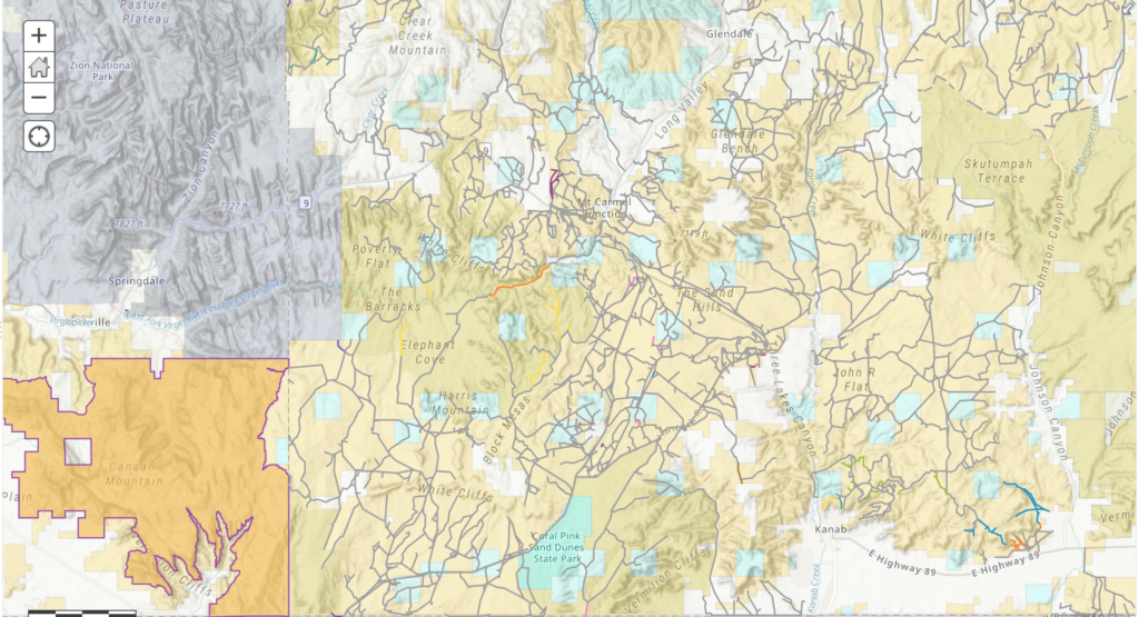
The BLM is currently analyzing a massive trail network in an area called Trail Canyon. This area is northwest of Kanab Utah and includes the areas surrounding the Coral Pink Sand Dunes, the Barracks Trail, and many other great riding areas. If this is an area you have explored, we need your help to submit comments to the BLM for the scoping period for this area.
This map shows the trails being analyzed. If you notice any trails missing from this map, we need your feedback. Also, if you like riding anywhere in this area, it would be good for you to take a few minutes of time and let the BLM know that you use the trails that are there and would like to keep them open.
https://www.arcgis.com/home/webmap/...f2b&extent=-112.9751,36.9823,-112.525,37.1787
You can share your feedback with the BLM by clicking the Participate Now button on this link: https://eplanning.blm.gov/eplanning-ui/project/2003332/530
The deadline for commenting is November 30, 2020, so we need to get the comments in ASAP. Contact us if you need assistance or have specific feedback you would like us to incorporate in our comment that we plan to submit.
Continue reading...
We have been actively engaged in protecting access for motorized access during this process. In order to get as many people involved we created the 10,000+ Project, where you can sign up to assist us with public comments, route inventory analysis, and other activities that allow us to work together to protect access.
https://www.sharetrails.org/current-issues/10000-project-keep-utah-open/
Also, as we’ve seen the initial decisions for the first areas analyzed by the BLM, we learned that in addition to opposing motorized access to public lands, the anti-access groups are investing a lot of resources into reducing or eliminating dispersed camping on public land. We know that dispersed camping is one of the most popular forms of recreation on public land, and it is form of recreation that many take for granted. Based on the legal challenges we have seen from anti-access groups, if those who enjoy dispersed camping don’t start participating in this process we will lose access to this cherished form of recreation. We invite everyone who loves the open and free experience of camping on public land to join the Dispersed Camping Access Alliance to assist us as we fight to keep our public lands open for dispersed camping.
The BLM is currently analyzing a massive trail network in an area called Trail Canyon. This area is northwest of Kanab Utah and includes the areas surrounding the Coral Pink Sand Dunes, the Barracks Trail, and many other great riding areas. If this is an area you have explored, we need your help to submit comments to the BLM for the scoping period for this area.
This map shows the trails being analyzed. If you notice any trails missing from this map, we need your feedback. Also, if you like riding anywhere in this area, it would be good for you to take a few minutes of time and let the BLM know that you use the trails that are there and would like to keep them open.
https://www.arcgis.com/home/webmap/...f2b&extent=-112.9751,36.9823,-112.525,37.1787
You can share your feedback with the BLM by clicking the Participate Now button on this link: https://eplanning.blm.gov/eplanning-ui/project/2003332/530
The deadline for commenting is November 30, 2020, so we need to get the comments in ASAP. Contact us if you need assistance or have specific feedback you would like us to incorporate in our comment that we plan to submit.
Continue reading...