The Moab Field Office of the Bureau of Land Management recently released its range of alternative maps for the Labyrinth Rims and Gemini Bridges. At least two of these Alternatives have unacceptable levels of closures for this area. This is an incredibly popular area for all forms of recreation that is located north west of Moab.
For a good background of what’s at stake with this area, our executive director, Ben Burr, discussed the planning process for this area at length on the Dirt Bike Channel podcast. You can listen to it here:
We have also made Freedom of Information Act requests for the public comments from anti-access groups, so we can learn in advance what they will be fighting to close. We are sharing this comment in full, so you can learn the arguments that are used to restrict access. Pay close attention to the maps that appear at the end of this document. These maps highlight the routes and areas that they want to see closed for motorized access.:
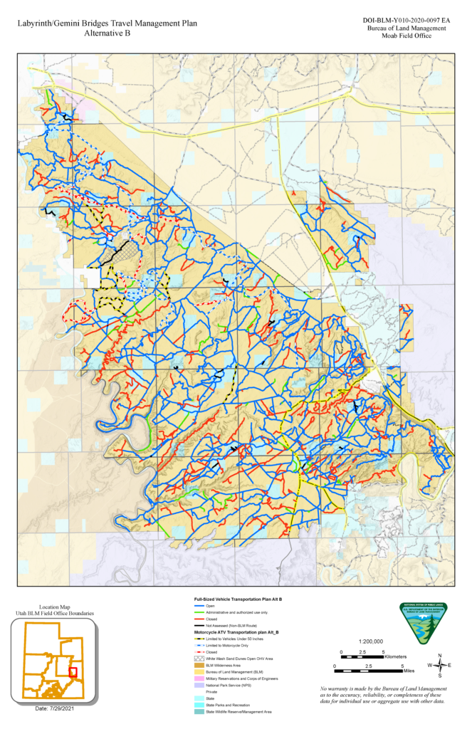
If you skip to the end of the comment above you’ll find in the maps that the anti-access groups are definitely advocating to close a substantial number of routes and trails in this popular area. Many of the areas they are proposing to close are included in the Red Rock Wilderness Act, which is a bill proposal that has never passed into law. There is no reason that the BLM should be considering legislative proposals for land management decisions. Nevertheless, it is clear the BLM is doing just that in Alternative B:

If you ride in Moab, you need to become very acquainted with the map above. If any of the routes that you enjoy riding appear in red, we need you to join the 10,000+ Project today. These maps are the preliminary maps, and the full plan will be released for public comment in the coming months. We will make sure the all members of the 10,000+ Project are informed and ready to submit substantive comments to keep these areas open.
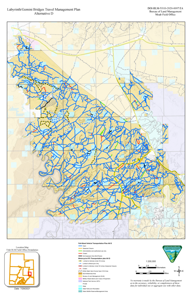
Of the Alternative maps released, Alternative D is the most reasonable – but even this alternative unnecessarily closes routes. Here is a map of Alternative D, so you can compare the difference between the most restrictive version and the least restrictive version:
While we wait for BLM to release the draft plan and begin the next public comment period there are a few things you can do to help BlueRibbon Coalition and our allies fight to keep these areas open:
Help BlueRibbon Coalition/ShareTrails Protect Off-road access in Montana
Continue reading...
For a good background of what’s at stake with this area, our executive director, Ben Burr, discussed the planning process for this area at length on the Dirt Bike Channel podcast. You can listen to it here:
We have also made Freedom of Information Act requests for the public comments from anti-access groups, so we can learn in advance what they will be fighting to close. We are sharing this comment in full, so you can learn the arguments that are used to restrict access. Pay close attention to the maps that appear at the end of this document. These maps highlight the routes and areas that they want to see closed for motorized access.:
If you skip to the end of the comment above you’ll find in the maps that the anti-access groups are definitely advocating to close a substantial number of routes and trails in this popular area. Many of the areas they are proposing to close are included in the Red Rock Wilderness Act, which is a bill proposal that has never passed into law. There is no reason that the BLM should be considering legislative proposals for land management decisions. Nevertheless, it is clear the BLM is doing just that in Alternative B:
If you ride in Moab, you need to become very acquainted with the map above. If any of the routes that you enjoy riding appear in red, we need you to join the 10,000+ Project today. These maps are the preliminary maps, and the full plan will be released for public comment in the coming months. We will make sure the all members of the 10,000+ Project are informed and ready to submit substantive comments to keep these areas open.
Of the Alternative maps released, Alternative D is the most reasonable – but even this alternative unnecessarily closes routes. Here is a map of Alternative D, so you can compare the difference between the most restrictive version and the least restrictive version:
While we wait for BLM to release the draft plan and begin the next public comment period there are a few things you can do to help BlueRibbon Coalition and our allies fight to keep these areas open:
- Join the 10,000+ Project – we will be releasing updates on this area and several more areas in the coming weeks.
- Go explore these areas and document the status of the red roads on either of these Alternatives. Anti access groups will claim the routes are unused and reclaiming to justify closing them. We need to be able to show that they are used.
- We have also seen anti-access groups illegally block roads in other areas to make them look closed. They then claim the routes are reclaiming. If you see any routes blocked with wood, debris, deadfall, or boulders, please take pictures, note the GPS coordinates and contact us. We will work with the BLM to make sure illegally closed roads are not blocked.
- Finally, we are currently involved in legal challenges to keep other areas near this area open. We can be assured if BLM doesn’t choose a restrictive option on this plan that their decision will be challenged in court. We are hoping to get 1,000 $5 a month donors to help us fund our legal challenges to keep these areas open. If you haven’t already become a recurring donor to our 10,000+ Project legal fund, we hope you will make a generous contribution to this effort.
Help BlueRibbon Coalition/ShareTrails Protect Off-road access in Montana
Continue reading...